


Guru Maps — GPS Route Planner
4.4163.00 Reviews
App Specs
- Version
- 5.9.2
- Updated On
- License
- Free
- Downloads
- 1,000,000+
- Developer
- Evgen Bodunov
- Categories
- Travel & Local
- Platform
- Android, iOS
Screenshots
 Analysis by AppCompare
When I try a navigation app for the first time, I want to know two things quickly: whether I can make sense of the map and whether I can still use it when my connection drops. Guru Maps — GPS Route Planner is built around that practical combination. It is a free travel and local app from developer Evgen Bodunov, with offline map use at the heart of its appeal. I would consider it for a trip where I want to plan ahead, rather than rely on a phone signal appearing exactly when I need it.
Getting comfortable with the map
Downloading Guru Maps was a breeze, and the setup was straightforward. I loved how the interface was clean and intuitive. Even if you're not tech-savvy, you'll feel right at home navigating through the options. The app is designed to make route planning a piece of cake, whether you're driving, cycling, or walking.
What to expect on your first trip
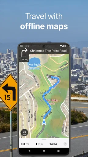
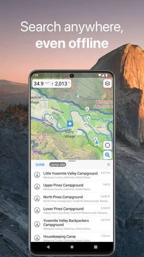
The key thing to understand before setting off is that offline navigation depends on preparation. You need to download the map area you expect to use while you still have a reliable connection. That changes the routine a little compared with opening a familiar online map and searching on the spot, but it is a worthwhile habit for travel through rural areas, underground stations, or unfamiliar neighborhoods where mobile data can be patchy.
Guru Maps has a 4.4 average from around 13 thousand ratings, and it has passed a million installs. Those figures suggest it has found an audience beyond a small group of mapping enthusiasts, though popularity alone does not tell me whether its workflow suits every traveler. Its current version is 5.9.2, and the app is rated for Everyone. The core download is free, while in-app purchases range from $2.99 to $89.99 per item, so I would check what a paid option includes before treating every advanced need as part of the free experience.
Make the first setup useful
My advice is to choose a map area based on a real outing rather than trying to prepare for an entire holiday at once. Search for the place you plan to visit, make sure the relevant area is available offline, and then inspect it before you leave home. That simple check helps you notice whether your intended start point and destination are both covered. It also avoids the frustrating discovery that you downloaded a map but not the area you actually need.
Map downloads are best treated as part of trip planning, not as an emergency fix after you lose signal. If you are heading out for a day walk, for example, save the area around the trailhead and the nearby roads you might need for the return. Keep your phone charged, too: offline maps remove the need for a data connection, but they do not remove the need for a working device or GPS reception.
The first successful route
One of the standout features is the offline maps. Yes, you heard that right—offline! No more worrying about losing signal in remote areas. Just download the maps you need, and you're good to go. This is perfect for those spontaneous trips when you’re out of reach of Wi-Fi or data.
Worth Reading Before You Choose

Flipboard Shows What News Apps Must Do Beyond the Feed

Switching to Android Auto Means Rethinking Your Driving Routine

Google Calendar Makes a Crowded Week Easier to Manage

Ludo King Makes the Most of the Minutes Between Plans

Baby Panda World Brings Quick Play to Modern Phones, but Its Game Library Feels Busy

ESPN’s Live Game View Makes Following Close Games Easier
For a first test, I would plan a short route in a place I already know. That lets me focus on how the map presents the route and how the directions feel, without adding the stress of being somewhere unfamiliar. Try a walk between two local landmarks, then deliberately take a different street or miss a turn. Seeing how the app responds during a low-stakes outing is a more useful test than trusting it for the first time on a long drive.
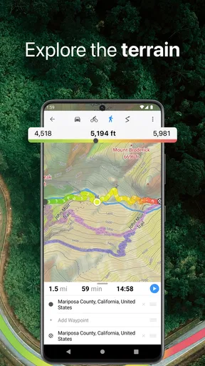
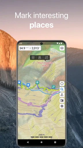
Another great feature is the detailed route planning. You can customize your routes, add waypoints, and even choose from different transport modes. I particularly enjoyed the elevation profiles for cycling and hiking. It’s like having a personal tour guide in your pocket.
Planning beyond the obvious route
Waypoints are useful when a destination is only one part of the plan. I would use them to mark a café, a scenic stop, or a place where a group intends to meet, then consider the route as a sequence instead of a single point-to-point instruction. For a long ride, the elevation profile can help me compare two possible routes before I commit. A shorter option is not always the easier one if it includes a climb that changes the feel of the day.
There is a trade-off here: detailed planning rewards a little thought before departure. If I only need the quickest drive to a familiar shop, all those choices may be unnecessary. If I am building a day around several stops or trying to understand the shape of a cycling route, they become much more valuable. The app makes more sense to me when I use those planning tools intentionally rather than treating every journey as a full expedition.
Following directions and handling mistakes
The real-time navigation is spot on. Turn-by-turn directions are clear, and you get a heads-up for traffic conditions. Plus, the voice guidance is available in multiple languages, which is super handy for international travelers. I took it for a spin around town, and it rerouted me quickly when I made a wrong turn. No fuss, no stress.
Even with clear instructions, I would keep an eye on the map in a complicated junction or pedestrian area. Voice guidance is most helpful when I can listen without repeatedly looking down, but a spoken prompt cannot replace paying attention to signs, road rules, or the surroundings. On a trip with passengers, one person can handle the route while the driver concentrates on driving; on foot, I prefer to stop somewhere safe before checking a turn I am unsure about.
Choosing a map style and sharing plans
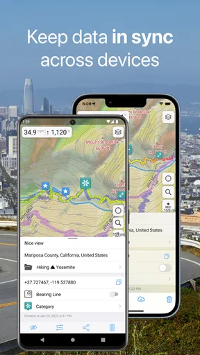
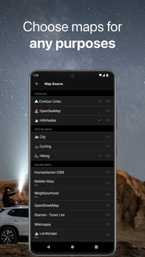
Customization is where Guru Maps shines. You can choose from different map styles and switch between them depending on your needs. The app also allows you to import and export routes, which is perfect for sharing travel plans with friends or preparing for a group trip.
A practical workflow is to settle on a style before the journey, then use a different one only when it answers a particular need. A familiar-looking map can be easier to scan while walking through a city, while another view may make more sense when reviewing a route in advance. I would also test route import or export before a group trip rather than leaving it until everyone is waiting at the starting point. Sharing a route is useful only if each person can open and understand it on their own device.
- Offline Maps
- Customizable Routes
- Real-Time Navigation
- Multiple Language Support
Where it fits among navigation apps
Compared with the usual map apps people open for everyday directions, Guru Maps puts more emphasis on preparing maps and routes for travel where connectivity may be uncertain. A mainstream online map can be quicker when I just need a nearby business or a fast route through town, especially if I have a stable connection and do not want to plan ahead. Guru Maps is the more interesting choice when offline access, waypoints, and route preparation matter more than finding a place in the moment.
That distinction is important for first-time users. I would not replace every familiar navigation app automatically: keep the one you already rely on for quick local searches if it serves that purpose well. Instead, try Guru Maps for a specific trip and see whether its offline planning fits your habits. It is especially appealing for hikers, cyclists, and travelers who like to check a route before leaving. It is less compelling for someone who only wants the simplest possible turn-by-turn drive and has dependable data everywhere they go.
Everyday example: a day out of town
Imagine taking a train to a town you have never visited, then walking from the station to a guesthouse, a trail entrance, and a lunch stop before heading back. I would download the relevant map while connected at home, add the stops I care about, and look over the walking route before boarding. Once there, I could follow the plan without needing to keep searching for a signal. If the group changes its mind, I can use the map to orient myself and decide what to do next rather than treating the original route as a fixed itinerary.
For a cycling version of that day, the elevation profile gives me a way to think about effort before setting out, while a waypoint can preserve a planned rest stop. The useful insight is not simply that an offline map exists; it is that combining preparation with a few meaningful route markers makes the phone a steadier reference when plans shift. I still would not use a screen while moving through traffic or technical terrain. Check the map when stopped, and keep the real-world route and conditions in view.
Compatibility, performance, and practical limits
Whether you're using an Android or iOS device, Guru Maps has got you covered. The app runs smoothly on both platforms, and I didn’t experience any crashes or lagging. It’s lightweight yet powerful, so it won’t drain your battery or hog your storage space.
That is my experience, not a promise that every phone or long outing will behave identically. Navigation can use battery, and storing offline maps uses device space, so I would make room and start a long journey with a charged phone. The app supports Android devices running version 5.0 or later. If you are buying a new phone specifically for travel, check its own battery and GPS performance as well; an app cannot compensate for a device that is already struggling.
Another cool perk is its compatibility with external GPS receivers, which can boost accuracy in tricky terrains. If you love trekking or mountain biking, this feature is a godsend.
An external receiver is a niche advantage rather than a must-have for everyone. Most casual city walks do not call for extra equipment, and carrying another device adds its own setup and charging considerations. I would first try the app with the phone I already own, then consider an external receiver only if location accuracy is a recurring problem in the environments I visit. This keeps the first outing simple and avoids buying gear before I know I need it.
Support and a sensible learning curve
Let’s talk about community support. The app has a vibrant user community where you can share tips and tricks or seek advice. Plus, the customer support team is responsive and helpful. I had a couple of questions about importing maps, and they got back to me swiftly with detailed instructions.
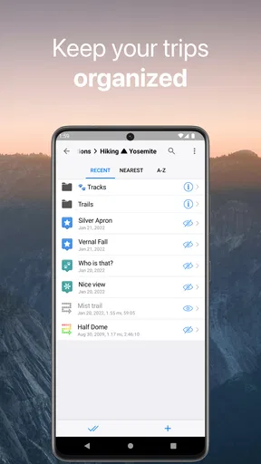
For a new user, I would keep the first session focused: download one map area, create one short route, and learn how to get back to the map screen. After that, try one extra task, such as adding a waypoint or moving a route between devices. Taking those steps separately makes it easier to spot whether a confusing moment comes from the map itself or from a feature you have not used before. If an import workflow is central to your plans, test it early and ask for help before travel day.
Who should choose it—and who may not need it
I would recommend Guru Maps to people who enjoy preparing for a trip, want maps ready before entering a low-signal area, or regularly plan walking and cycling routes with several stops. It can also suit travelers who want a route they can inspect in advance rather than follow blindly. The free starting point makes it possible to explore the basic workflow before deciding whether an in-app purchase is relevant to your needs.
I would skip it, or at least keep another navigation app handy, if my main task were finding shops and services on the fly in a city with reliable data. Someone who dislikes downloading maps, adjusting route details, or checking settings may find a simpler online-first alternative more convenient. Likewise, if a journey depends on live information, I would not assume an offline map alone covers every changing condition. I would prepare a backup plan for important travel and verify the route before leaving.
Final thoughts
In the world of navigation apps, Guru Maps — GPS Route Planner is a gem. It’s reliable, versatile, and packed with features that cater to all kinds of travelers. Whether you’re a city dweller or a nature lover, this app will guide you every step of the way. So, if you're planning your next adventure or just want a trusty navigational sidekick, give Guru Maps a try. You won't be disappointed!
Ready to explore the world without getting lost? Download it today and embark on your next journey with confidence!
Pros
- Offline maps available for global use.
- Highly customizable map settings.
- Fast and responsive interface.
- Detailed route planning capabilities.
- Works without an internet connection.
Cons
- Premium features require a subscription.
- Limited real-time traffic updates.
- Occasional GPS signal issues reported.
- Complex interface for new users.
- High battery consumption during use.
FAQs for Guru Maps — GPS Route Planner
What are the main features of Guru Maps?
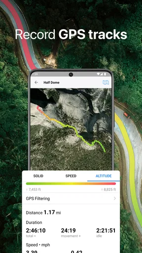
Guru Maps offers offline maps, detailed GPS navigation, and route planning for travelers. It includes features like turn-by-turn directions, voice guidance, and customizable routes. Users can also access topographic maps, download maps for offline use, and track their journeys. The app supports a wide range of map formats, making it versatile for various needs.
Is Guru Maps available offline?
Yes, Guru Maps is designed to work offline. Users can download maps for any region or country and access them without an internet connection. This feature is particularly useful for travelers in remote areas or those looking to save on data consumption while navigating through unfamiliar territories.
How accurate is the GPS navigation in Guru Maps?
The GPS navigation in Guru Maps is highly accurate, offering real-time tracking and precise turn-by-turn directions. Users can rely on the app for detailed information on their current location, and the app's ability to update routes quickly ensures that users can respond to traffic changes or detours efficiently.
Can I customize my routes in Guru Maps?
Yes, Guru Maps allows users to customize their routes. You can add multiple waypoints, avoid toll roads, or choose alternative routes based on personal preferences. This flexibility makes it suitable for both casual users and those with specific navigation needs, such as cyclists or hikers.
What platforms is Guru Maps available on?
Guru Maps is available on both Android and iOS platforms. It provides a seamless experience across devices, ensuring that users can access their maps and routes regardless of the device they are using. Regular updates enhance functionality and compatibility with the latest operating systems.


